Detalls del llibre
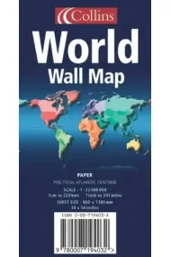
LAMINATED EDITION An ideal reference map that covers the whole World, showing the political units on every continent. Scale 1:22 000 000; 1 cm to 220 km; 1 inch to 347 milesMAIN FEATURES Political map showing individual countries including roads, railways and physical features. Continents shown by individual colour. AREA OF COVERAGE All of the world, centred on the Greenwich Meridian. WHO THE PRODUCT IS AIMED AT Home and business reference user. Also available rolled in tube, and encapsulatedEXAMPLES OF UPDATES: Asia: Reduced area of Aral Sea now shown Malaysia: Putrajaya shown as joint capital South Africa: Tshwane shown as alternative name for Pretoria Australia: new railway line from Alice Springs to Darwi
Llegir més - Autor/a NOT KNOWN
- ISBN13 9780007194049
- ISBN10 0007194048
- Any Edició 2004
- Fecha de publicación 01/06/2004
- Idioma Alemany, Francès
Ressenyes i valoracions
Sigues la primera persona a valorar-lo!
Has llegit WORLD WALL MAP POL ATL LAM IN?


WORLD WALL MAP POL ATL LAM IN (Alemany, Francès)
- De
- NOT KNOWN
- |
- Zondervan Academic (2004)
- 9780007194049
18,52€
19,50€
-5%
Enviament Gratuït
No disponible
18,52€
19,50€
-5%
Enviament Gratuït
No disponible


Devolució gratuïta

 Gràcies per comprar a llibreries reals!