Detalls del llibre
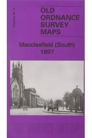
Here are the details of maps for Macclesfield (South): Cheshire Sheet 36.12 Macclesfield (South) 1897 - published 2001; intro by Chris Makepeace. ISBN.978-1-84151-282-2 This detailed map covers the southern part of Macclesfield, with coverage stretching from Derby Street southward to Byron's Lane, and from Oxford Road eastward to Blakelow Road. Features include railway but no stations, Park House, Sutton Pottery, Sunnyside Mill, Sutton Mills, Soho Mill, Macclesfield Canal, Hovis Flour Mill, St Paul's church, St John's church, Library, St George's church, Christ Church, Militia Barracks, Oxford Road Mill, silk mills, etc. The map links up with Cheshire sheet 36.08 Macclesfield North to the north.
Llegir més - Autor/a Chris Makepeace
- ISBN13 9781847848321
- ISBN10 184784832X
- Any Edició 2026
- Fecha de publicación 10/05/2026
- Idioma Alemany, Francès
Ressenyes i valoracions
Sigues la primera persona a valorar-lo!
Has llegit Macclesfield (South) 1897: Cheshire Sheet 36.12?


Macclesfield (South) 1897: Cheshire Sheet 36.12 (Alemany, Francès)
- De
- Chris Makepeace
- 9781847848321
4,32€
4,55€
-5%
No disponible
4,32€
4,55€
-5%
No disponible


Devolució gratuïta

 Gràcies per comprar a llibreries reals!